From Sydney

Whitewater rivers for day trips from Sydney


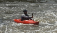
The Australian Kayak School has compiled a list of places close to Sydney, where you can kayak whitewater rivers.

Please remember there is an element of risk involved when paddling in fast moving water. It is important you and your paddling buddies are properly trained and skilled and have all necessary equipment to stay safe in the environment you are paddling in.

Check out our courses for upskilling.The Australian Kayak School has a range of whitewater kayak lessons, courses and programs to give you the competence and confidence to kayak whitewater rivers. The  Australian Kayak School also offers a guiding service, talk to us about a whitewater river kayak guide

For inquiries please contact us with your location, paddling history/experience and what you wish to achieve

phone/sms 0450832430

email bookings@kayakschool.com.au

Duration may vary on water levels and scouting time..

Features may change. If in doubt get out of kayak and scout ahead.

!

Nepean River - McKees Rd to Bents Basin Rd

!

Nepean River (Wallacia area) 

McKees Rd, Theresa Park to Bents Basin Rd, Wallacia

 1hr from Sydney


Grade: 3

Length: 7km

Duration: 2 - 3hr

Level: 0.3 Wallacia weir

Gauge: http://www.bom.gov.au/cgi-bin/wrap_fwo.pl?IDN60143.html

Put in: End of McKees Rd on right is a walking path beside a paddock to the river.

Take out: End of Bents Basin Rd. Bents Basin, A big pool immediately after the last rapid. There is a bubbler water tap in this picnic area.

Shuttle: 35km paved, check street directory

Description: The flatwater at the start is tiring then you get to the weir and portage on river left. The first whitewater rapid is soon after. Second rapid onwards you can scout on river right, beware of trees in rapids. Sydneys best whitewater secret, shhh.

Nepean River - Nortons Basin

!

Nepean River (Wallacia area) 

Nortons Basin, Nortons Basin Rd, Wallacia

 1hr from Sydney


Grade: 2

Length: 300mtrs

Duration: As long as you want

Level: 0.3 Wallacia weir

Gauge: http://www.bom.gov.au/cgi-bin/wrap_fwo.pl?IDN60143.html

Put in: End of Nortons Basin Rd follow steep walking path down to the river.

Take out: Follow path back to carpark.

Shuttle: Not required

Description: Popular in summer for locals as a swimming hole. Carry kayak up side of rapids for as many runs as you like.

Kangaroo River - Hampden Bridge to Bendeela Rec Park

!

Kangaroo River (Kangaroo Valley)

Hampden Bridge to Bendeela Rec Park 

2-5hrs from Sydney


Grade: 2

Length: 7km

Duration: 4hr

Level: 0.7 Hampden Bridge Gauge

Gauge: http://www.bom.gov.au/cgi-bin/wrap_fwo.pl?IDN60144.html

Put in: Upstream under bridge

Take out: Bendeela Rec Park

Shuttle: Bendeela Rd 8km paved

Description: A fun beginners river, half dozen grade 1-2 rapids,

Kangaroo River - Flatrock to Gerrigong Ck Bridge

!

Kangaroo River (Kangaroo Valley) 

Flatrock to Gerrigong Creek Rd Bridge 

2.5hrs from Sydney


Grade: 3

Length: 5km

Duration: 2hr

Level: 0.75 Hampden Bridge Gauge

Gauge: http://www.bom.gov.au/cgi-bin/wrap_fwo.pl?IDN60144.html

Put in: End of Upper Kangaroo River Rd before a gate, put in on big flat rock

Take out: Under gerrigong ck rd bridge

Shuttle: 5km gravel from Gerrigong Creek Rd bridge along Upper Kangaroo Rd, this runs along the river most of the way.

Description: Great fun whitewater river, can get a bit pushy in the boulder garden rapid, keep an eye out for fallen trees. The waterfall rapid can be scouted. A few nice play waves dependant on the level.

Barrington River - Rocky Crossing to Thunderbolts Way

!

Barrington River (Gloucester area) 

Rocky Crossing to Thunderbolts Way  

3.5 hrs from Sydney


Grade: 1+

Length: 10km

Duration: 4hr

Level: 0.45 Rocky Crossing Gauge 50m upstream of crossing

Gauge: http://hits.nsw.gov.au/jsp/hits2data.jsp?site=208006

Put in: Barrington West Rd meets Rocky Crossing causeway, put in on downstream side river right.

Take out: Under Thunderbolts Way Bridge

Shuttle: 8km paved/ gravel along Barrington West Rd from just after Thunderbolts Way bridge to Rocky Crossing causeway

Description: A sweet intro whitewater experience for new paddlers, a fair bit of flatwater between rapids.

Barrington River - The Cove to Rocky Crossing

!

Barrington River (Gloucester Area)

The Cove to Rocky Crossing

3.5 hrs from Sydney

Grade: 2

Length: 6km

Duration: 2hr

Level: 0.45 Rocky Crossing Gauge 50m upstream of crossing

Gauge: http://hits.nsw.gov.au/jsp/hits2data.jsp?site=208006

Put in:  The Cove (signposted) along Manchester Rd.

Take out: Rocky Crossing

Shuttle: 8km gravel along Manchester Rd from just before Rocky Crossing causeway

Description: Plenty of narrow tree lined sections and nice not too challenging Grade 2 rapids. A nice warmup for the section from Binderra to the Cove.

Barrington River - Binderra to The Cove

!

Barrington River (Gloucester Area) 

Binderra to The Cove 

3.5 hrs from Sydney


Grade: 2+

Length: 8km

Duration: 2.5hr

Level: 0.45 Rocky Crossing Gauge 50m upstream of crossing

Gauge: http://hits.nsw.gov.au/jsp/hits2data.jsp?site=208006

Put in: Binderra farm at end of Manchester Rd (knock on house on right of driveway and  say hi, a couple dollars to park on property by the water)

Take out: The Cove (signposted) along Manchester Rd.

Shuttle: 16km gravel along Manchester Rd right turn off Barrington West Rd from just before Rocky Crossing causeway

Description: A beautiful section of whitewater river, some technical rapids requiring a bit of skill, section includes The Steps rapid which can be scouted river left and run a few times. A grassy bank immediately after The Steps rapid is a good lunch spot.